


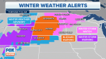
Blizzard warnings and winter storm watches are in effect for dozens of counties across the Northern Plains Monday as the National Weather Service is warning that the region could soon be slammed with its "biggest snowstorm of the year."
The notices stretching from Nebraska to Minnesota come as FOX Weather is forecasting 1 to 2 feet of wind-driven snow across the Dakotas with accumulations possibly topping 2 feet in portions of South Dakota.
"Numerous forms of widespread hazardous weather are anticipated to affect the western and central U.S. early this week as a large and powerful storm system begins to strengthen over the Intermountain West on Monday before pushing into the central Plains by Tuesday," the National Weather Service said in an advisory.
"Setting the stage for what could be the biggest snowstorm of the year across parts of the Northern Plains will be a deep and highly anomalous upper-level low swinging from the Intermountain West to the Central Rockies on Tuesday," it added.
TORNADOES, HAIL KILL AT LEAST 26 AS CRUSHING STORMS ASSAULT MIDWEST
The NWS says the "impressive late season snowstorm" will first impact a "wide expanse of the central and northern Rockies through Tuesday afternoon, with the greatest snowfall totals likely across the higher terrain of Utah, Wyoming, and Colorado where 1 to 3 feet of accumulation is looking probable.
"High wind warnings are also in effect from southern California to New Mexico, and extending northward into parts of southern Utah and Colorado where wind gusts will likely exceed 50 mph at times," it said.
An NWS advisory said on Tuesday, a "highly anomalous April snowstorm with blizzard conditions is expected from northwestern Nebraska and across the central Dakotas and then into northern Minnesota."
FORMER ARKANSAS GOV. HUCKABEE GIVES UPDATE ON HOME STATE’S ‘DEVASTATING’ TORNADOES
"Severe travel disruptions and hazards to livestock in the region are anticipated on Tuesday and even extending into early Wednesday," it warned.
The blizzard warnings and winter storm watches stretching through the nation’s midsection remain in effect until Thursday morning.
In places such as northern Nebraska, NWS forecasters are predicting up to 16 inches of snow, wind gusts of nearly 60 mph, whiteout conditions and scattered power outages.
Wind chills near or below zero also are expected across the Plains and upper Midwest, according to FOX Weather.
It is forecasting the heaviest snowfall to occur along a line stretching northeast from Casper, Wyoming, to Grand Forks, North Dakota.
"With the strong front across the Plains moving eastward, there will be a temperature dichotomy with much below average readings across basically all the western U.S. and northern Plains, with many locations from the northern Rockies to the Dakotas staying below freezing all day Tuesday," the NWS said.
