


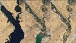
A drought scorching Las Vegas and the rest of the Southwest continues to deplete water levels in Lake Mead, making areas that once were underwater now visible from space.
NASA released images of Nevada's Lake Mead on Wednesday showing the lake's rapid decline of water since 2000. NASA noted in the release that water levels at Lake Mead currently stand at the lowest since April 1937. The reservoir last reached capacity in the summer of 1999, according to NASA.
JAMES WEBB SPACE TELESCOPE FINDS CANDIDATES FOR EARLIEST GALAXIES
When full, Lake Mead can reach an elevation of 1,220 feet and holds 9.3 million gallons (36 trillion liters) of water. Currently, the reservoir behind the Hoover Dam is 1,041 feet above sea level.
"Lake levels at the dam should stay above a 1,000 feet to continue operating hydropower turbines at normal levels" NASA said.
UNUSUAL RADIO SIGNAL DETECTED BY ASTRONOMERS BILLIONS OF LIGHT-YEARS AWAY
Lake Mead is the United States' largest reservoir, providing water to millions of people across seven states, tribal lands and northern Mexico.
In addition to serving as a major drinking and irrigation source, Lake Mead provides recreational activities for its community. The National Park Service was forced to close five of the six boating ramps and launches due to the low levels of water.
"Declining water levels due to climate change and 20 years of ongoing drought have reshaped the park’s shorelines," the National Park Service announced on its website. "As Lake Mead continues to recede, extending launch ramps becomes more difficult and more expensive due to the topography and projected decline in water levels."
